
About the opportunity
What this programme is offering
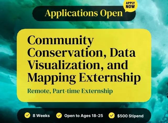
The externship is designed to make conservation education accessible to young people worldwide. Open to applicants from all countries, the programme requires a commitment of approximately 10 hours per week over eight weeks.
Because the programme is fully remote, all live meetings and events are recorded, allowing participants to engage flexibly regardless of their time zone or personal commitments.
By combining conservation science, mapping technology and storytelling, the externship aims to equip participants with practical skills that can support future careers in sustainability, environmental policy, research, education and science communication.
Learning From Two Global Conservation Leaders
Participants will learn directly from experts at the National Geographic Society and The Nature Conservancy, two internationally recognized organizations committed to protecting biodiversity and promoting sustainable development.
Throughout the programme, participants will explore major environmental issues affecting communities around the world while learning how geography and spatial data can support conservation efforts.
Key conservation topics include:
Biodiversity conservation
Marine ecosystem protection
Freshwater conservation
Community-based environmental solutions
Geographic approaches to sustainability
The programme emphasizes connecting global environmental challenges with local realities, encouraging participants to identify conservation priorities within their own communities.
Hands-On Training in GIS and Mapping
A major component of the externship focuses on developing practical Geographic Information Systems (GIS) skills using industry-standard Esri mapping technologies.
Participants will receive foundational training in:
Geographic Information Systems (GIS)
Spatial data analysis
Digital mapping
Data visualization
Geographic storytelling
Esri StoryMaps creation
No previous GIS experience is required, making the programme accessible to beginners interested in learning how mapping technologies contribute to environmental conservation.
Developing Community Conservation Solutions
Rather than focusing solely on theory, participants will investigate conservation challenges affecting their own regions.
Working throughout the programme, they will:
Research local environmental issues.
Collect and analyze geographic data.
Identify community conservation opportunities.
Design place-based conservation solutions.
Present findings using interactive digital maps.
By applying geographic analysis to real-world issues, participants will strengthen their ability to develop practical, locally relevant conservation strategies.
Building Communication and Storytelling Skills
Effective conservation depends on clear communication, and the externship places strong emphasis on science communication and public engagement.
Participants will learn how to:
Present research findings confidently.
Translate complex scientific information into accessible stories.
Communicate conservation challenges visually.
Create compelling digital narratives using maps.
Deliver presentations to diverse audiences.
The programme culminates in the creation of an Esri StoryMap, allowing participants to combine research, geographic data and visual storytelling into a professional-quality project.
Skills Participants Will Gain
Throughout the eight-week experience, participants will build valuable technical and professional competencies, including:
Conservation literacy
GIS fundamentals
Geographic data visualization
Primary and secondary research
Community-based problem solving
Public speaking
Scientific communication
Cross-sector collaboration
Systems thinking
Digital storytelling
These transferable skills are increasingly valuable across environmental, research, policy and nonprofit careers.
Portfolio-Ready Experience
One of the programme’s most significant benefits is the opportunity to develop work that can strengthen future academic and professional applications.
Participants will produce:
An Esri StoryMap.
Conservation research findings.
Data visualization projects.
Mapping portfolio pieces.
Community-focused conservation recommendations.
These deliverables can be showcased in university applications, scholarship submissions, internship opportunities and
Study Grants & Scholarships
Who Can Apply?
The externship welcomes young people who are curious about environmental protection and eager to make a difference in their communities.
Study Grants & Scholarships
Applicants must:
Be between 18 and 25 years old.
Be located anywhere in the world.
Be available for approximately 10 hours per week.
Have an interest in conservation, science communication or community advocacy.
Be willing to complete the full eight-week programme.
Importantly, applicants do not need prior experience in GIS, mapping or conservation. Curiosity, enthusiasm and a willingness to learn are considered the most important qualifications.
However, previous participants in National Geographic Society and The Nature Conservancy externships are not eligible to apply again.
Why This Externship Stands Out
The programme combines flexible online learning with practical project work and mentorship from globally respected conservation organizations.
Participants will benefit from:
Fully remote participation.
Flexible scheduling.
Expert-led learning.
Global peer networking.
Practical GIS training.
Real-world conservation projects.
Professional portfolio development.
A US$500 educational stipend upon successful completion.
For aspiring environmental professionals, researchers, educators and sustainability advocates, the externship offers an accessible pathway into conservation while developing highly sought-after skills in mapping, research and science communication.
How to apply